Identifying and tackling climate challenges at the local level
- November 11, 2024
- 9 min. Reading time

How are different types of settlements and their populations particularly threatened by climate change and its consequences? What strategies are there for increasing their resilience? These are the questions the Urban Climate Future Lab (UCFL) is investigating.
Using an interdisciplinary and transdisciplinary approach, the UCFL team aims to identify where there is an urgent need for action in towns and communities in Lower Saxony. In a second step, integrated climate adaptation strategies will be developed from a multidisciplinary perspective and with local stakeholders. In the interview, UCFL spokesperson Prof. Vanessa Carlow explains what makes up the urban system of Lower Saxony and why there needs to be a shift in focus in climate adaptation.
Hello Prof. Dr. Carlow, you are the director of the Institute for Sustainable Urbanism at TU Braunschweig, spokesperson for the research focus Future City and now also spokesperson for the Urban Climate Future Lab. What is the research interest of this climate future lab?
We are dealing with the connection between climate change and urbanisation and, building on this, with climate adaptation strategies and measures. To do this, we want to make the leap from large-scale global and regional climate models to specific local challenges on the ground. We are focusing on Lower Saxony. With the UCFL, we want to investigate how the urban system in its elements, i.e. the types of settlement typically found in Lower Saxony, from large cities, medium-sized and small towns to municipalities and villages, are influenced by climate change and what role landscape, mobility, production and governance play in climate adaptation. On this basis, we will develop tailor-made climate adaptation strategies for specific types of settlement – with partners from the field and on the ground. We hope that our research results will later be transferable to similar urban systems worldwide.
What characterises the urban system of Lower Saxony?
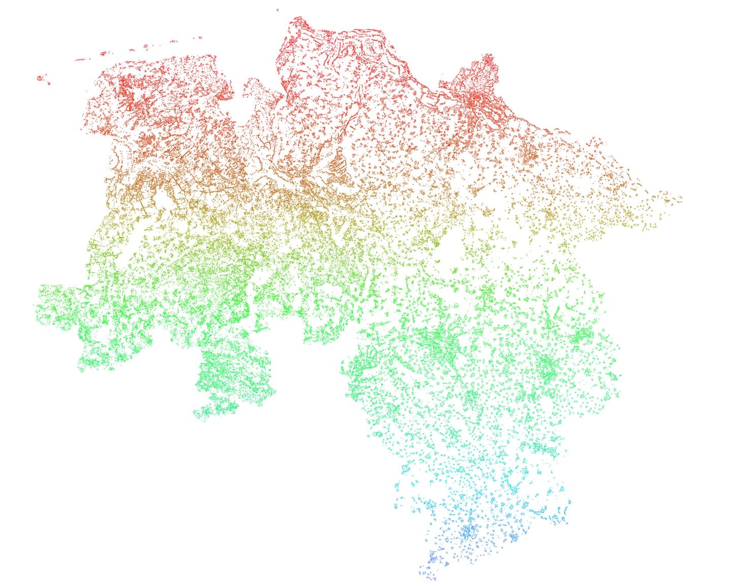
In past research projects, we have dealt very intensively with Lower Saxony. We have developed a method to describe the urban system. We call this method topoi[*] (Further information on the Topoi method: Carlow, V., Mumm, O., Neumann, D., Schneider, A.-K., Schröder, B., Sedrez, M., & Zeringue, R. (2022). TOPOI – A method for analysing settlement units and their linkages in an urban–rural fabric. Environment and Planning B: Urban Analytics and City Science, 49(6), 1663-1681. https://doi.org/10.1177/23998083211043882). It is based on the classification of urban-rural settlement types into thirteen Topoi classes, using a set of very life-like indicators, such as the built density, accessibility by public transport or the presence of facilities such as daycare, school, shop or bus stop. This method provides us with a better understanding of the interrelations and linkages between urban and rural areas[*] (Further information: Carlow, V., Abou Jaoude, G., Karadag, C., Mumm, O., Scheer, M., Schöning, K. & Zeringue, R. (2023). METAPOLIS. TOPOI. SCENARIOS: for Urban-Rural Sustainability in Lower Saxony. Berlin, Boston: JOVIS. https://doi.org/10.1515/9783868599886).
In this context, we understand an urban system to be the network of different types of settlements and their various linkages. Settlement types can be, for example, large cities, medium-sized towns, small towns, joint municipalities, a village, a hamlet and everything in between. However, we do not find any million- or megacity regions in Lower Saxony. ‘Connections’ refers to how these settlement types of different sizes, functions and accessibility are networked and interact with each other, i.e. what flows of people, goods and information exist between them. If we visualise this urban system for Lower Saxony, a number of things are characteristic, for example, that most people do not live in large cities, but in small and medium-sized towns and in suburban areas. We also have many regions that are characterised by rural and agricultural landscapes, with towns and villages dotted around, so to speak. According to our hypothesis, this specific urban system (and others like it) face particular challenges in the face of climate change and therefore require specific solutions.
What is the UCFL focusing on? The interaction between the different types of settlement, or the individual types of settlement?
Both. The sustainability discourse in urban development has been focused on large cities and megacity regions for a very long time. There are already a great variety of strategies for dealing with sustainability and climate adaptation. So far, there are only a few really good solutions for small and medium-sized towns, as well as polycentric regions, whose challenges in the context of climate change are different. The challenges faced by these cities are closely linked to the landscape in which they are located, for example. We are specifically looking for solutions of this kind.
So does this mean that every city or settlement has its own climate-related challenges depending on its location?
Yes and no. Certainly, many or all places in Lower Saxony will be more affected by heat and heavy rainfall and even a combination of the two, to name just two examples. But Lower Saxony is characterised by a wide variety of landscapes. We have low mountain ranges like the Harz, heathland, landscapes heavily influenced by rivers and their regulation, coastal regions, agricultural landscapes and many more. Some of these landscapes are changing dramatically. When I think back to last winter, I remember flooding and river flooding in and around Braunschweig. For months, cellars, gardens and agricultural land were also under water in Bröckel, a village where a dear colleague of ours lives. Then in the summer there were wildfires in the Harz region. So everyone in Lower Saxony can report on their own experiences with changes in the landscape, extreme events and their effects on their own lives. We want to help people understand this better, but also work on concrete measures and adaptation strategies.
Are there locations or regions you want to focus on with the Climate Future Lab (Klima.Zukunftslabor UCFL)?
To start our project work, we want to examine which regions or places in Lower Saxony are particularly affected by the consequences of climate change. Where do heat, flooding, extreme weather, etc. occur particularly frequently? To do this, we are drawing on data from our partner, the GERICS – Climate Service Center Germany.
We then overlay this data with our topoi method and see if there are certain types of settlement that are highly vulnerable. This enables us to search for local partners within our network, with whom we can then work on climate adaptation strategies at the local level and using examples.
It is therefore important to explain our typological approach again. We will never be able to develop participatory strategies and measures for all places in Lower Saxony as part of our project. But since places are planned, they are similar to a certain extent, just as buildings are similar to a certain extent. That's where we start. Are there evidence-based measures that work just as well in Bröckel as they do in Brome? Are there ideas for Salzgitter that also work well in Peine and Vechelde? What can Hannover learn from Lüneburg? Lower Saxony, but also from research and examples of application worldwide.
What are the characteristics of a city or municipality that is particularly vulnerable?
This can best be visualised using the example of heat or flooding. There are wonderful data sets that show us where heat or flooding occurs particularly frequently. I could name a few specific places for Braunschweig. For Bremen, which as a federal state is surrounded by Lower Saxony, as well as along the Lower Saxony coastline, we know, for example, that flooding due to rising sea levels will be a problem in the future.
In the project, we actually want to use the large or regional models to zoom in on exemplary villages and towns, almost with a magnifying glass, in order to understand and address the challenges of climate change.
What will be the end result of this process?
We want to go beyond recommendations for action. The goal is to develop basic knowledge on the one hand. And to continue to work together with cities, municipalities, NGOs, citizens and other relevant stakeholders and to actually initiate climate adaptation projects.
I can also imagine exploring whether landscape elements should play a greater role in governance in the future. Regions are currently organised in a radial system. You have a core city, around which suburbs, small towns, etc. are arranged. But perhaps we need to break away from this way of thinking and align ourselves more along landscapes or rivers, as is already the case in the area of coastal and dike protection.
Climate protection and climate adaptation measures often end at the city limits. With our Topoi method, we can understand the urban system independently of administrative boundaries. We expect this method to provide more realistic results. In our daily lives, we hardly notice city limits. And for climate change, a city limit is totally irrelevant!
Are there best-practice examples of cities where climate adaptation strategies are being implemented well that you can use as a guide?
Singapore, where we at the ISU, together with the IWF, which are also part of the UCFL, have helped to establish a research presence for TU Braunschweig, is certainly a prime example of how a city can adapt to climate change in the shortest possible time. Very good examples of climate adaptation projects and decarbonisation have been initiated or already implemented there. However, Singapore's climate is hardly comparable to that of Lower Saxony. We are, after all, in a tropical region there. But the questions of how Singapore manages water, how it deals with heavy rainfall or combats heat islands, can serve as a good example. In general, the process from scientific problem analysis to solution in Singapore is very well and efficiently designed.
Another example that I find outstanding is actually New York. The city began to gradually rebuild the city and, in particular, to transform the coastal areas so that they serve as a buffer, at the latest with Hurricane Sandy, when parts of the city near the coast were flooded. Social aspects also play a major role here, because the floodplains of the Bronx and Brooklyn are mainly inhabited by poorer sections of the population.
What methodologies will you use?
Since we are an interdisciplinary team, we combine a variety of methods. Among others, we have natural scientists, engineers, psychologists, architects and urban planners in our laboratory. Each of these specialist fields naturally also brings its own methodologies and approaches. Combining these approaches is a challenge that we are happy to take on and look forward to.
Have you already made contact with the cities and municipalities you want to work with?
At my institute, we have been working with cities and municipalities in Lower Saxony for a long time and intensively. When I was appointed to TU Braunschweig thirteen years ago, I published an open call with the Institute for Sustainable Urbanism via the Lower Saxony Association of Cities. We offered to help towns and municipalities to address their challenges by working with them to develop solutions. In particular, smaller towns and municipalities have contacted us to tackle problems such as vacancies. As a result, we have contacts with numerous localities that geographically range from the Harz Mountains to the North Sea coast.
In the first phase of the project, we want to investigate where there is a particular need for action based on climate data and people's experiences. If we can identify specific places or regions here, we will activate our network there and see if we have local partners with whom we can implement projects.
What will the initial phase of the joint project look like?
Apart from the obligatory job postings, we are currently holding many discussions in the lab and will coordinate the specific next steps and start our joint work in an internal kick-off for our lab at the end of October. There we will discuss the collaboration with everyone involved and define our common goals. Especially in the first project phases, we will meet a lot so that we can get everyone involved on board and make the work process productive. We are very happy that Dr Esteban Muñoz, a great scientist and science manager, has agreed to manage our Lab. Dr Muñoz brings with him an incredible amount of expertise and experience from global institutions and will be a great asset to us here in Braunschweig.
I am sure I speak for the entire UCFL team when I say that we are incredibly excited about our Lab! We look forward to tackling the challenges together as a team. We are aware of our responsibility! As scientists, we are united by the unconditional will to be able to make a positive contribution to the sustainable development of our cities and communities! We look forward to cities and communities as well as stakeholders from civil society and business in Lower Saxony contacting us if they find our approach exciting and would like to join us!
Thank you for the interview.
Contact

More Posts
All
Laser scans in the forest: measuring CO₂ between red beeches and deadwood
What a windless morning, 1,000 square meters of forest, and a laser scanner reveal about carbon storage.
4 min. Reading time
Job opening at DIVERSA
PhD position in the Vegetation Ecology and Biodiversity Conservation working group
1 min. Reading time
ZKfN guest at the “Get active now” seminar
The “Get active now” seminar brings together knowledge, commitment, and social practice.
2 min. Reading time